Great News for The HomePort Journals
 Madeline Sorel has agreed to an illustration especially for The HomePort Journals!
I couldn’t be more delighted. We’ll be working together to create a map of Provincetown specifically designed to place key locations within the novel. The map will appear on this website as well.
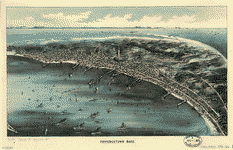
The 1910 map shown here is one possible style under consideration. The challenge is to evoke the whaling days of yore while showing many of those current-day places where the drama takes place. We’re in the early phases of the design, but I’m hopeful our map will show the variety of nature, humanity, and history that coexist in our town. One of the most amazing things about P’Town is how much variety is compressed into such a small amount of land. Many folks visit for years never knowing of the lakes, dune shacks, forests, and trails that are just minutes away. They see Commercial Street and think that’s all there is. (And, in all honesty, many of us locals like it that way!) The world of HomePort reflects all parts of Provincetown, the madness and mayhem, but also the quiet places where one can go to regain equilibrium. My characters could not exist without those moments of introspection and the times when nature provides the answer they’ve been searching for.
I’ve enjoyed Madeline’s work for years. Her clients include the New York Times, Knopf, Random House, J.C. Penney, Glamour and Cosmopolitan. This will be a joyous labor of love, and I just can’t stop smiling when I think about it.
A C

Photo © 2022 Ric Ide
www.acburch.com
- A. C. Burch On Writing - December 15, 2017
- Join Me at the 2nd Annual Provincetown Book Festival Sept 15 & 16th 2017 - September 12, 2017
- Provincetown Heroes - May 28, 2017
Leave a Reply
Want to join the discussion?Feel free to contribute!